
Benteng Puteri Ijo
Namu Rambe, Kab. Deli Serdang, Sumatera Utara
A World Class Heritage Site Under Threat
Field Report, May 2008.
E. Edwards McKinnon
Ph.D., M.A., FRAS, FSAS
Fig 1.
The Medan Region: Belawan to Deli Tua (Benteng Puteri Ijo).

The Medan Region: Belawan to Deli Tua (Benteng Puteri Ijo).
Recent developments at Namu Rambe, Kabupaten Deli Serdang suggest that a World Class Heritage site, the Benteng Puteri Ijo, or Fortification of the Green Princess may be under threat from development. This series of earthen ramparts and ditches is unique in the area around Medan, the provincial capital of North Sumatra province though similar constructions may exist elsewhere in the province such as the Padang Lawas area southeast of Medan.
Unfortunately, and ironically in Visit Indonesia Year 2008, this important site, distinguished by impressive earthen ramparts and ditches, extends along the south bank of the Deli river where the river transforms into the Lau Petani, the Karo name for the stream which rises on the slopes of the Gunung Sibayak. It appears to be under threat from development. For some unknown reason the site does not appear to be listed in the Inventory of Ancient Sites for Aceh and North Sumatra held by the BP3 Aceh and Sumatera Utara based in Banda Aceh.
Benteng Puteri Ijo is associated with the Legend of the Green Princess, a folk hero claimed by both Karo and Melayu ethnic groups. According to the Karo, Puteri Ijo was boru Sembiring (a member of the merga Sembiring, one of the five Karo clans) who came from the village of Siberaya, Urung Sukapiring, on the Karo plateau. She married the Raja Aru who ruled at Deli Tua – a settlement that formerly existed where the ramparts now stand. Aru was attacked by Aceh and the ruler killed by subterfuge and treachery. His wife fled into the surrounding forest on the back of an elephant and eventually made her way to Johor, where she married the ruling Sultan who helped her oust the Acehnese and regain her kingdom. A sixteenth century account by the Portuguese writer Pinto states that Aru was conquered by the Acehnese in 1539 and recounts how the Queen of Aru made her way to Johor and the events that transpired thereafter.
Evidence for former habitation at the Benteng Puteri Ijo site exists in the form of ceramic sherds and other artefacts which may be found on the surface of the ground within the settlement area, though many have been pulverised due to repeated ploughing for agricultural activities. Miksic (1979) describes the topography and characteristics of the area as follows:
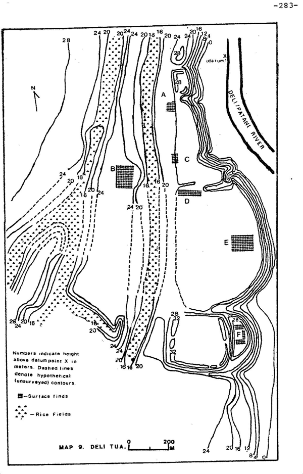
“This site is on the fifty-meter elevation contour; here the land rapidly begins to rise above the featureless Deli plain, and thus marks an important point of topographic transition. …. The main features of the site are two large earthen fortifications 1.2 kilometres apart (see map, attached). Both utilize the near-vertical west bank of the Deli river as part of the defense.
The local topography is composed of a number of parallel and very narrow ridges, on which houses are located and crops such as maize and tapioca are grown. Between the ridges, in equally narrow valleys, are irrigated rice fields. These ridges and the intervening valleys are each less than a hundred meters wide, but stretch north and south for several kilometers. The tops of the parallel ridges are ten to fifteen meters above the padis.”
Miksic goes on to describe two defensive features, one 150 X 60 metres in extent at the northern end of the complex and another feature some 300 metres square. At the time he undertook his survey, the area was heavily overgrown and he would appear not to have seen other defensive features which now, with more clearing having taken place in the intervening years, are more readily apparent to the observer. The earthworks would thus appear to be much more extensive than reported in 1979, as the additional south-facing natural features of the area have been enhanced and strengthened for defence subsuming an extensive defensive complex some 1800 metres in length and of varying depth. The actual extent of the settlement complex requires further survey and verification.
The intervening valleys mentioned above are actually former river beds, abandoned courses of the Lau Petani, which have considerably broken up the terrain to the south of the fortifications. The construction of the fortifications show remarkable ingenuity in the adaptation of the terrain for defensive purposes, enhancing the natural slope of the land and by the planting of impenetrable clumps of bamboo along the crests of the ramparts. These latter are largely in the process of being destroyed but some remnants still give a vivid impression of the original strength of the ramparts.
Miksic’s map shows some six locations within the general area of the former settlement where cultural remains were to be seen in 1979. It appears however, that the area of cultural remains is actually much more extensive than reported earlier, as traces of sherd material may now be found in cultivated fields, even beyond the Medan / Namu Rambe road.
The site of a spring, now known as the Pancuran Puteri Ijo, where Puteri Ijo reputedly went to bathe is located on the southeast side of the complex, a short distance from the Lau Petani and below an entrance feature, well-protected by steep and powerful ramparts. The spring is now acknowledged as a keramat where Medan folk go to burn incense and to ask for favours.
Ceramic sherd material recovered from the settlement area comprises Chinese wares, the earliest of which date from the late Song (1127-1279) and Yuan (1280-1368), Ming (1368-1644) and Qing (1644-1912) periods, Burmese, Thai Si Sachanalai (Sawankhalok) and Sukhothai wares and Vietnamese wares. The Ming material comprises both Longquan celadons and Jingdezhen blue and white wares. A Burmese green on white sherd, extremely rare in a Southeast Asian export context, has been recovered within the fortification area.
Sherd recoveries at Deli Tua relate to finds of similar materials at Kota Rentang, an extensive early Islamic site located west of Hamperan Perak and some 6 to 8 kilometres from Kota Cina, the latter an 11th to late 13th or early 14th century riverine harbour site located between the Sungei Deli and the Belawan rivers. Kota Cina related material, including recoveries of Chinese coins, has been recovered at both Deli Tua and Kota Rentang.
There are also considerable amounts of locally produced earthenware. Of the latter, Miksic (1979) writes:
“The pastes of earthenware from Deli Tua fall into three types. The most common type contains a striking amount of iron pyrite which causes the surfaces of ost of these sherds to glitter with numerous golden flecks. These sherds come mainly from the simple thick-walled, wheel-formed bowls (see drawing 114). One variety has traces of a red slip on the exterior, and anvil marks on the interior.
The second type is nearly as common. Little or no pyrite exists in these sherds, but mica is quite common. Vessels were mostly flaring-rimmed cooking pots, some with rim designs similar to Kota Cina vessels, and many sherds bear traces of red slip. Some sherds come from smaller unslipped vessels.
The third type is rare, and the paste includes both pyrite and mica, though the pyrite is not as abundant as in the first type described. These sherds have a much smoother feel, because of the finer grained paste. No shapes can be reconstructed. One sherd has a paddle-marked impressed herringbone design.”
Locally made earthenwares would normally display quantities of volcanic glass, derived from the volcanic tuff (cadas) which forms much of the bedrock of the north Sumata area, a legacy of the tremendous Toba eruption of some 60 to 70,000 years ago.
Miksic observed that no one area within that surveyed contained any unusual concentrations of sherd material of any one type or period. He thus assumed that areas near to the northern and southern fortifications were inhabited contemporaneously – evidence which suggests a near continuity of occupation over a period of six to seven hundred years from at least the c14th, if not earlier, to the present.
Over the centuries Deli Tua was an important node in the route between the coast and the plateau, with a trail leading up past Limau Mungkur to Bukum and the Cingkam pass.
The name first appears in European literature in a report by John Anderson who visited Deli in 1823, where he notes that “At Delli Tuah, or Old Delli, there are the remains of an old fort, with large square stones, the walls thirty feet in height, and two hundred fathoms in circumference. Rajah putri Iju, the celebrated princess, is stated to have built it. It is now, however, in a very imperfect state; and possibly my information as to the size may be incorrect.” (Anderson 1971: 292). Anderson did not personally visit Deli Tua and reference to stone-built defences was an exaggeration, but the site was obviously well known in the folk memory of the period.
In 1866, Deli Tua was visited by the Dutch Colonial Controlleur, Van Cats, Baron de Raet, who passed through on his way to the Karo plateau (Van Cats: 1875: 173-175). He found it surprising that so many people could be housed in so few dwellings. His description of the area includes a note of a lela or Malay bronze cannon that was found imbedded in the earthen ramparts and which bore an inscription in Jawi (Arabic) script, “Sanah 1004 (?) alamat balon Haru” which Lau Husni (n.d.) affirms is a mixture of Malay and Karo. The date was initially thought to be 1104, which transcribes as 1691 C.E. but, as the name Aru disappears completely in the early sixteenth century when it was conquered by Sultan Iskandar Muda of Aceh in 1612, the date in all probability should read 1591 C.E.. The cannon is thought now to be in the collections of the Museum Nasional, Jakarta. On his return, Van Cats purchased a lead cannon shot from the penghulu for 5 guilders.
Over the years, numerous small Acehnese gold coins known as dirham have been found scattered over the Benteng Puteri Ijo site. A single Chinese coin of the Zhenzong emperor, of the period 1111-1118 C.E. together with a fragment of Song period qingbai porcelain were found at the southern end of the fortification complex.
A small modern village, occupied by Karo people is located within the ramparts at a location known as Deli Tua Lama. Here the ridge is some 250 metres in width and cut by a two metre high rampart and a ditch, in which is a point where a five metre causeway across the ditch allows access to the village (Miksic 1979).
Benteng Putri Ijo 2008
Bibliography:
Anderson, John
1971 Mission to the East Coast of Sumatra. Kuala Lumpur: Oxford in Asia Reprints.
Lau Husny, Tengku
n.d. (1975). Lintasan Sejarah Peradaban dan Budaya Penduduk Melayu Pesisir Deli Sumatera Timur 1612-1950. Medan: Printed privately.
Miksic, John N.
1979 Archaeology, Trade and Society. Cornell University: Ph.D. Dissertation.
Van Cats, J.A.M., Baron de Raet
1875 “Reize in de Battaklanden in December 1866 en Januarij 1867”
Tijschrift v. h. Bataviaasch Genootscap. 22. 164-219.
—- * —-

You must be logged in to post a comment.